Basic Core Spatial Math Example
Note
Bing Maps Web Control SDK retirement
Bing Maps Web Control SDK is deprecated and will be retired. Free (Basic) account customers can continue to use Bing Maps Web Control SDK until June 30th, 2025. Enterprise account customers can continue to use Bing Maps Web Control SDK until June 30th, 2028. To avoid service disruptions, all implementations using Bing Maps Web Control SDK will need to be updated to use Azure Maps Web SDK by the retirement date that applies to your Bing Maps for Enterprise account type. For detailed migration guidance, see Migrate from Bing Maps Web Control SDK and Migrate Bing Maps Enterprise applications to Azure Maps with GitHub Copilot.
Azure Maps is Microsoft's next-generation maps and geospatial services for developers. Azure Maps has many of the same features as Bing Maps for Enterprise, and more. To get started with Azure Maps, create a free Azure subscription and an Azure Maps account. For more information about azure Maps, see Azure Maps Documentation. For migration guidance, see Bing Maps Migration Overview.
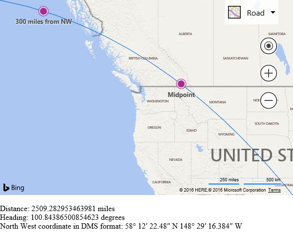
The following example shows how to use a number of the core Spatial Math functions. It uses north west and south east coordinates of the map to calculate a geodesic line between these points (line that follows the curvature of the earth), the midpoint of this line, a point that is 300 miles from the north west coordinate along the line, the length of the line, the heading between the coordinates, and the also converts the north west coordinate into Degree Minute Second format.
<!DOCTYPE html>
<html>
<head>
    <title></title>
    <meta charset="utf-8" />
	<script type='text/javascript'>
    function GetMap() {
        var map = new Microsoft.Maps.Map('#myMap', {
            credentials: 'Your Bing Maps Key',
            zoom: 4
        });

        //Load the Spatial Math module.
        Microsoft.Maps.loadModule("Microsoft.Maps.SpatialMath", function () {
            var bounds = map.getBounds();

            var northWest = bounds.getNorthwest();
            var southEast = bounds.getSoutheast();

            //Calculate a geodesic path between the two points (line that follows the curvature of the earth).
            var path = Microsoft.Maps.SpatialMath.getGeodesicPath([northWest, southEast]);
            var poly = new Microsoft.Maps.Polyline(path);
            map.entities.push(poly);

            //Calculate the midpoint of the line.
            var midPoint = Microsoft.Maps.SpatialMath.interpolate(northWest, southEast);
            var pin = new Microsoft.Maps.Pushpin(midPoint, {
                title: 'Midpoint'
            });
            map.entities.push(pin);

            //Calculate a location that is along the path 300 miles from the north west coordinate.
            var point300MilesFromNW = Microsoft.Maps.SpatialMath.getLocationAlongPath(poly, 300, Microsoft.Maps.SpatialMath.DistanceUnits.Miles);
            var pin2 = new Microsoft.Maps.Pushpin(point300MilesFromNW, {
                title: '300 miles from NW'
            });
            map.entities.push(pin2);

            //Calculate the distance from the northWest coordinate to the southEast coordinate.
            var distance = Microsoft.Maps.SpatialMath.getDistanceTo(northWest, southEast, Microsoft.Maps.SpatialMath.DistanceUnits.Miles);

            //Calculate the heading from the northWest coordinate to the southEast coordinate.
            var heading = Microsoft.Maps.SpatialMath.getHeading(northWest, southEast);

            //Convert the northWest coordinate into Degree Minute Second format.
            var northWestDMS = Microsoft.Maps.SpatialMath.toDegMinSec(northWest);

            document.getElementById('outputPanel').innerHTML = 'Distance: ' + distance + ' miles<br/>Heading: ' + heading + ' degrees<br/>North West coordinate in DMS format: ' + northWestDMS;
        });
    }
    </script>
    <script type='text/javascript' src='http://www.bing.com/api/maps/mapcontrol?callback=GetMap' async defer></script>
</head>
<body>
    <div id="myMap" style="position:relative;width:600px;height:400px;"></div><br/>
    <div id="outputPanel"></div>
</body>
</html>
Running this code will display a map with a geodesic line, with two pushpins on it. Below the map some calculated values are displayed.